Plan Development and Purpose
The Meramec River is one of the longest free-flowing rivers in the United States. The drainage basin for the Meramec is nearly 4,000 square miles of central and eastern Missouri. The Lower Meramec watershed runs from Sullivan, Missouri through the southern part of the St. Louis metropolitan area and enters the Mississippi River near the city of Arnold.
2017 Watershed Plan
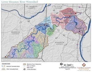
In 2017 East-West Gateway Council of Governments (EWG) updated the 2012 Lower Meramec Watershed Management Plan and added two more 12-digit Hydrologic Unit Code (HUC12) watersheds, Sugar/Fenton Creeks and Pomme/Mattese Creeks, to the analysis. The planning area extends from Pacific in the west to the confluence of the Meramec River with the Mississippi River. Building on the framework established in the 2012 Plan, the 2107 Plan identifies new partners and projects, as well as a timeline for projects aimed at achieving the goals in the plan. It is a nine-element plan.
In May 2018 the U.S. Environmental Protection Agency (EPA) accepted the Kiefer Creek Nine Element Plan for Bacteria contained in this document with revisions made by the Missouri Department of Natural Resources (MoDNR) to Chapters I and III and Appendix B, Load Duration Curves and Pollutant Reduction Estimates for Streams in the Lower Meramec Watershed (prepared by MoDNR) for clarification purposes.
- May 2018 Lower Meramec Watershed Plan, Title Page and Chapter I
- May 2018 Lower Meramec Watershed Plan, Chapter III
- May 2018 Lower Meramec Watershed Plan, Appendix B
- All 2017 Lower Meramec Watershed Plan Documents (includes the original 2017 documents plus the May 2018 updates)
2012 Watershed Plan
In 2012 EWG completed the Lower Meramec Watershed Management Plan which provides a framework for maintaining and improving water quality with the Lower Meramec. The entire Meramec watershed is divided into 33 sub-watersheds which drain directly into the Meramec River. The 2012 Lower Meramec Watershed Management Plan specifically covers the four HUC12 watersheds between the city of Pacific and the city of Valley Park which includes Brush Creek; Fox and LaBarque Creeks; Hamilton, Carr, Flat, Forby, Antire and Kiefer Creeks; and Fishpot, Grand Glaize and Williams Creeks.
 In general, the watershed management approach takes into account the specific water resource (stream, river, lake) and the surrounding land from which the water drains. It considers how to protect, maintain and restore the natural environment by directing development toward areas which can support a particular type of land use and/or density.